
Besseggen
Besseggen is one of Norway’s most popular mountain hiking trails. National Geographic placed Besseggen on the Top20 list of the most beautiful hiking trails in the world (it’s actually Top19, you can find the full list here). And indeed, when you look at the photos of this place on the Internet, you cannot get over it. And if the photos look so amazing, what does this route have to look like in reality?
Get Directions
Besseggen is located in the Jotunheimen Mountains, where there are also, among others, the two highest peaks of Scandinavia: Galdhøpiggen (2469 m above sea level) and Glittertind (2452 m above sea level). The name Jotunheimen means House of Giants and refers to Scandinavian mythology. The trail itself, marked as demanding, runs between two turist lodges, Gjendesheim and Memurubu, located along shore of the 18 km long Gjende Lake. The most popular direction for passing Besseggen is from west to east, from Memurubu to Gjendesheim. However, to be able to start the march, you need to get to Memurubu, and the easiest way to do it is by water transport (170 kr for adult in 2021. Tickets can be ordered here). From the quay at Gjendesheim, fast passenger boats depart regularly between the three lodges (the two above-mentioned and the third, Gjendebu, at the western end of the lake). So it’s easiest to catch the morning cruise to Memurubu and go from there than to go from Gjendesheim, hoping to get there before the last boat course. The trail is 14 km long and has about 1,100 meters of elevation, and the most demanding section is located exactly in the middle of the route, on a narrow, steep ridge, which is overcome using all four limbs. Immediately after this climb, you will reach the top of Veslefjell (1743 m above sea level), which is the highest point of the entire trip. This trip takes 5-9 hours.
There is also quite an important thing to mention for those who want to visit Gjendesheim and cross Besseggen. It is about the availability of parking lots nearby. Only guests of the lodge can park on Gjendesheim, you can leave your car free of charge right next to the quay, but only for a maximum 2 hours. Paid parking is located over one kilometer from the quay and the rate from 2021 is 150 kr per day for a passenger car. The full price list can be found here. Shuttle buses run between the parking lot and the Gjendesheim, usually correlated with the hours of the boat departures. There is no parking at the Memurubu lodge for a simple reason: there is no road access in this place.
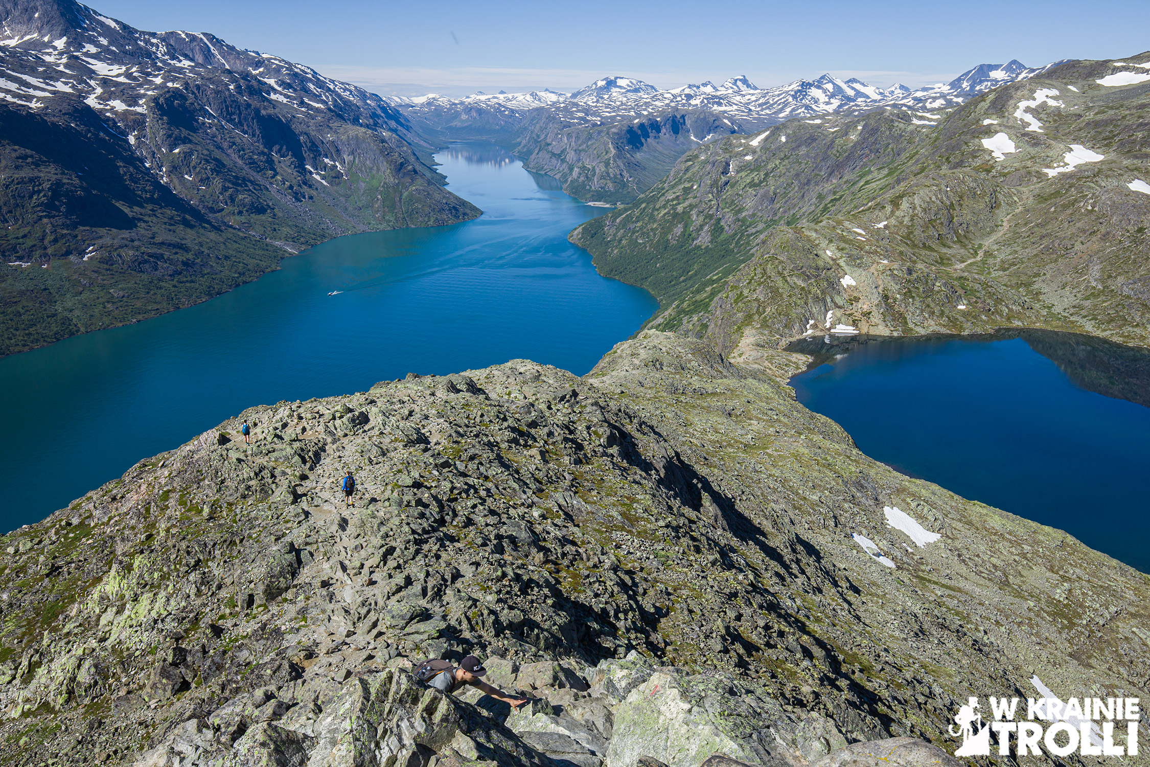
Gjende Lake has characteristic turquoise color, which is one of the main attractions of this place. This color in comparison with dark blue water of Bessvatnet Lake, 400 meters above, looks amazing. The trail leads on the narrow ridge between those two lakes.
One on the most exciting moments during the trip is the view of Knutshøe Mountain (1517 m above sea level). This mountain looks like part of extinct volcano with another lake in the crater.


Steep and narrow ridge before Veslefjell Mountain is the most dramatic part of this hike. But when you manage to climb on it, the rest of the way should be easy. There is a wide plateau around and walking on it make this part of the trail a little boring. But amazing views return during descending.
I must say, that walking along this trail I felt like one of the Lord of the Rings character. Spectacular views compensate for the hardships of the trip and the route is not as demanding as I afraid of. The second half of the trail is different from the first. The terrain on the plateau is flat, rocky and devoid of vegetation. And interesting views appear only on the descent. Overall, however, the impressions of the route remain in the memory for a long time and although I am still fresh after the trip while writing this text, I would gladly return there now.


